
SECTIONAL CHART GUIDE
How to Read Part 107 Sectional Charts
Do not try to read every mark at once. For a Part 107 chart question, use the same order every time: locate the point, identify the symbol or boundary, read its vertical meaning and units, then apply the current operating rule.
Locate
Find the stated airport, coordinate, area marker, or landmark.
Identify
Read color, line style, symbol, and which side of a boundary contains the point.
Resolve altitude
Separate MSL elevations from AGL heights and confirm feet or other stated units.
Apply the rule
Use the current regulation and operational conditions; the chart alone is not permission.
Worked example: FAA Figure 26, area 4
This is a cropped excerpt from the FAA's Airman Knowledge Testing Supplement, Figure 26. It is suitable for explaining the testing symbol shown here; it is not a current navigation chart and must not be used to plan a flight.
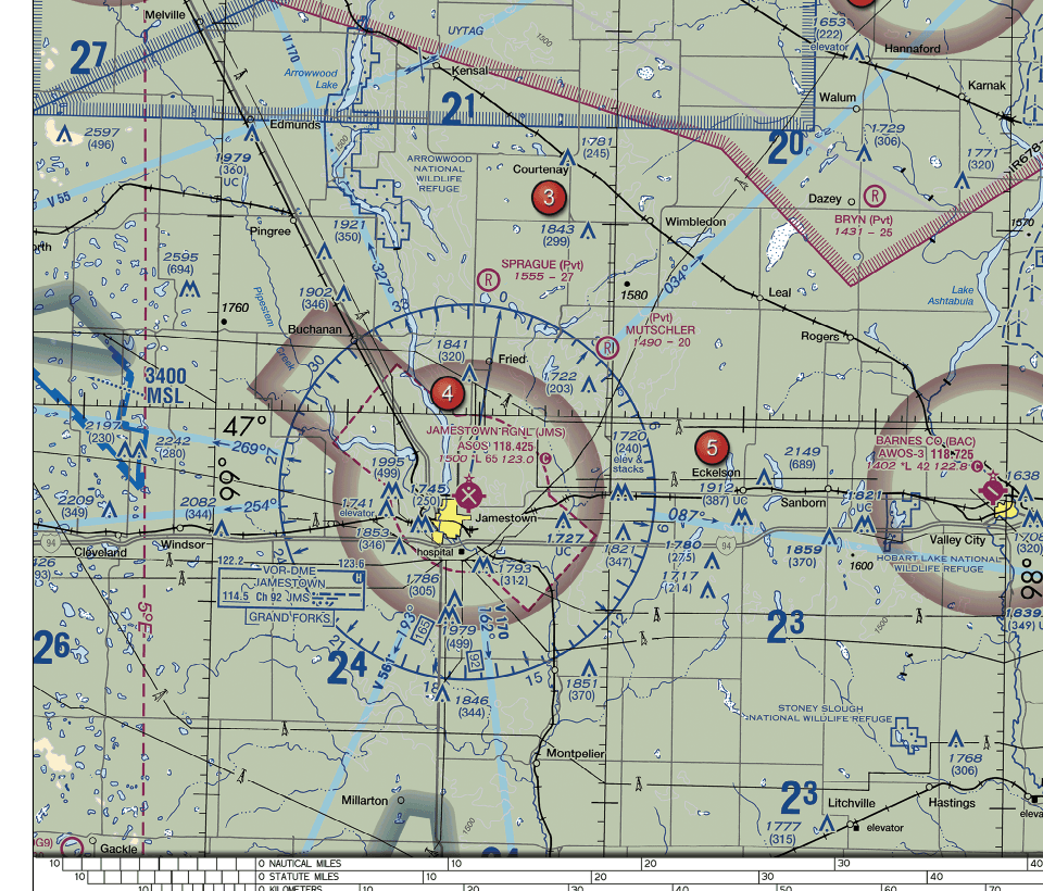
Step 1: locate the referenced area
The prompt directs you to area 4 near Jamestown Regional (KJMS). Keep the answer tied to that marked location; nearby airspace outside the boundary may have a different classification.
Step 2: read the boundary's color and line style
Area 4 lies inside a dashed magenta boundary. The FAA Aeronautical Chart User's Guide identifies dashed magenta as a Class E surface-area boundary. Do not substitute the meaning of a solid magenta Class C boundary or a dashed blue Class D boundary.
Step 3: state the scenario's vertical condition
The boundary in this example depicts Class E beginning at the surface at the marked location. That is different from the broader faded magenta vignette used to depict Class E beginning at 700 feet AGL. The question is about a Part 107 operation at area 4, not about an aircraft above a separate shelf.
Step 4: apply the current rule
Under current 14 CFR § 107.41, an operation in the designated surface area of Class E airspace requires prior authorization from Air Traffic Control. Therefore the supported answer is A. Class E surface area; prior ATC authorization is required. Staying below 400 feet AGL does not cancel that separate authorization requirement.
Keep MSL, AGL, and units separate
MSL is elevation above mean sea level. AGL is height above the local ground. FAA sectional chart elevations are normally in feet MSL unless otherwise indicated, while a parenthetical number beside a charted obstruction can show that structure's height in feet AGL.
Convert a flight height to MSL
In P107-S1-Q03, the ground is 620 feet MSL and the aircraft is 250 feet AGL directly above it. Add the references: 620 + 250 = 870 feet MSL.
Read an obstruction label
In P107-S2-Q02, 1549 above (310) means the top is 1,549 feet msl and the structure is 310 feet agl. Both values are feet; the reference changes.
Common beginner misreads
- Using color without line style. Solid magenta, dashed magenta, and a faded magenta vignette carry different meanings.
- Reading the nearby side of a boundary. Locate the exact point and decide which side contains it before naming the class.
- Treating every number as AGL. Charted elevations and airspace limits are commonly MSL; drone operating heights are often discussed in AGL.
- Treating a chart as authorization. A chart helps identify airspace and hazards; current rules, restrictions, and an authorization's terms determine whether the operation may proceed.
Self-check
A sectional chart prints 1549 above (310) beside an obstruction symbol. What do the two numbers mean?
- A. The top is 1,549 feet MSL and the structure is 310 feet AGL
- B. The structure is 1,549 feet AGL and the ground is 310 feet MSL
- C. The top is 1,549 meters MSL and 310 meters AGL
Show answer and reasoning
Answer: A. For a charted obstruction, the upper value is the elevation of its top above mean sea level. When known and displayed, the value in parentheses is the structure’s height above ground level.
Source locator: Effective July 9, 2026; VFR Terms and Symbols, LAND FEATURES (TERRAIN) AND OBSTRUCTIONS, printed page 11.
Practice the sequence with cited answers
Set 2 includes chart and airspace questions. It is a 10-question learning set, not a full-length mock exam or readiness prediction.
Figure sources and verification
The image is the project's legibility crop of FAA-CT-8080-2H Figure 26, Appendix 2, printed page 2-25. The supplement was published in 2018 and remained listed by the FAA for Remote Pilot testing when checked on October 6, 2026. Boundary meaning was checked against the FAA Aeronautical Chart User's Guide effective July 9, 2026; the rule application was checked against current 14 CFR § 107.41.
Educational content only. FAA excerpts on this page are not for navigation. AFOQT Lab is not affiliated with or endorsed by the FAA or the United States government.